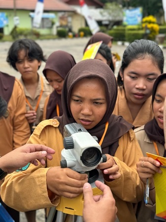
Pelatihan Auto Level untuk Survei Lokasi pada SMKN 4 SPP Singkawang
Auto Level Training for Location Survey at SMKN 4 SPP Singkawang
DOI:
https://doi.org/10.33084/pengabdianmu.v10i1.8393Keywords:
Auto Level, Topography, Agriculture, SurveyAbstract
SMKN 4 SPP Singkawang is one of the vocational schools that provides education with a focus on agriculture and agribusiness. The purpose of providing education at this school is to produce graduates who are skilled in agriculture. One of the important skills to have in agriculture is topographic surveying. For this reason, students at school are expected to have these skills. These skills can later be used to support various activities in agriculture, such as irrigation planning and determining plant types based on topographic conditions. Topographic surveys can be carried out effectively and efficiently using optical tools such as auto levels. Based on this, Community Service (PKM) activities in the form of auto level training were carried out by students at SMKN 4 SPP Singkawang. The purpose of this training is for students to be able to use auto levels in mapping land contours for agricultural and agribusiness purposes. The training began by providing an explanation of the optical tools that would be used for the survey. The next stage is for students to practice using the optical tools accompanied by the Community Service (PKM) team. The result of this training is that students are able to understand and practice measuring land contours using auto levels. Finally, this training is expected to improve the skills of students of SMKN 4 SPP Singkawang, which will later be able to support various activities in the fields of agriculture and agribusiness, such as irrigation planning, determining plant types, and so on.
Downloads
References
Amrullah, A., Prasetyo, V., Syahrir, M., & Efendi, R. (2024). Kajian Pemilihan Pompa Berdasarkan Karakteristik Topografi untuk Sawah Padi di Desa Bululondong. Majamecha, 6(1), 1–15. https://doi.org/10.36815/majamecha.v6i1.2967
Budiman, A. A., Jafar, N., Firdaus, F., & Munir, A. S. (2023). Pelatihan Pemetaan Topografi Menggunakan Auto Level dan Theodolite bagi Siswa SMK Budi Bangsa Luwu Utara Provinsi Sulawesi Selatan. Jurnal Tepat, 6(1).
Cahyaningprastiwi, S. R., Karyati, K., & Sarminah, S. (2021). Suhu Dan Kelembapan Tanah Pada Posisi Topografi Dan Kedalaman Tanah Berbeda Di Taman Sejati Kota Samarinda. Agrifor, 20(2), 189. https://doi.org/10.31293/agrifor.v20i2.5231
Cassiophea, L., & Nahan, V. A. (2022). The Use Of Waterpass For Student Of Modelling Design And Building Information (MDBI) Department At Smkn 1 Banama Tinggang, Pangi Village, Regency Of Pulang Pisau, Province Of Central Kalimantan. BALANGA: Jurnal Pendidikan Teknologi dan Kejuruan, 10(2), 45–48. https://doi.org/10.37304/balanga.v10i2.8093
Hartono, B. S., Efendi, M., & Sholeh, Moch. (2021). Perencanaan Ulang Jaringan Irigasi Tersier Menggunakan Lining Modular Pada Desa Pendem, Kecamatan Junrejo, Kota Batu. Jurnal JOS-MRK, 2(3), 273–279. https://doi.org/10.55404/jos-mrk.2021.02.03.273-279
Mukhlis, M., Alfansyuri, E., Lusyana, L., Suardi, E., & Mirani, Z. (2024). Pelatihan Teknologi Terbaru dalam Survey Pemetaan Lahan Pertanian untuk Guru SMK N 1 Koto Baru. Jurnal Pengabdian kepada Masyarakat, 3(1).
Nedra Neswita, Sahriyal Sahriyal, Sri Agustin, Arif Sudaryanto, Bobby Mauliantino, & Yelfidar Yelfidar. (2023). Pelatihan Pengetahuan Dan Keterampilan Menggunakan Alat Ukur Waterpass Untuk Peningkatan Kompetensi Siswa Kelas X Jurusan Teknik Konstruksi dan Perumahan SMKN 1 Rengat Barat Kabupaten Indragiri Hulu. Pandawa : Pusat Publikasi Hasil Pengabdian Masyarakat, 1(3), 38–46. https://doi.org/10.61132/pandawa.v1i3.67
Permana, F. A. (2021). Upaya Meningkatkan Pemahaman Materi Kesebangunan dan Kekongruenan melalui Metode Praktek Langsung. Jurnal Serambi PTK, VIII(5).
Purnomo, H., Nugraha, F. F., & Rahayu, G. D. S. (2021). The Effect Of The Hands On Activity Learning Model On Science Process Skills In Elementary School Students. 5(2).
Sambah, A. B., Kuncoro, D. A., & Anam, S. (2017). Pemetaan Trase Jaringan Irigasi Melalui Analisis Geospasial (Studi Kasus Daerah Irigasi Cibuluh, Jawa Barat). Jurnal Irigasi, 12(1), 1. https://doi.org/10.31028/ji.v12.i1.1-10
Sitohang, A., Panjaitan, J., Sinurat, W., Silitonga, M., Sitohang, O., & Sitindaon, C. (2021). Pelatihan Pengukuran Topografi pada Karyawan PT. Ligresa Lau Konsultan. Jurnal Pengabdian Kepada Masyarakat, 1(1).
Uguy, R., & Pangalila, L. (2022). Evaluasi Pengukuran Topografi Pada Proyek Jalan Manado Outer Ringroad III. Jurnal Ilmiah Realtech, 18(1), 25–31. https://doi.org/10.52159/realtech.v18i1.6
Wibowo, R. M. (2020). Leksikon dalam Aktivitas Pertanian Masyarakat Yogyakarta. SASDAYA: Gadjah Mada Journal of Humanities, 4(2), 105. https://doi.org/10.22146/sasdayajournal.59661

Downloads
Published
How to Cite
Issue
Section
License
Copyright (c) 2025 Irene Anggraini, Qalbi Hafiyyan, Etty Rabihati, Eva Ryanti, Ahmad Muhtadi, Ikhwan Arief Purnama, Randy Setiawan, Rizal Rizal, Hartanto Wahyu Sasongko, Imanuel Kemenangenta Perangin Angin

This work is licensed under a Creative Commons Attribution-ShareAlike 4.0 International License.
Authors who publish with this journal agree to the following terms:
- Any article on the copyright is retained by the author(s).
- Author grant the journal, right of first publication with the work simultaneously licensed under a Creative Commons Attribution License that allows others to share work with acknowledgment of the work authors and initial publications in this journal.
- Authors are able to enter into a separate, additional contractual arrangements for non-exclusive distribution of published articles of work (eg, post-institutional repository) or publish it in a book, with acknowledgment of its initial publication in this journal.
- Authors are permitted and encouraged to post their work online (e.g., in institutional repositories or on their websites) prior to and during the submission process, as can lead to productive exchanges, as well as earlier and greater citation of published work.
- The article and any associated published material is distributed under the Creative Commons Attribution-ShareAlike 4.0 International License


